- Cisco Community
- Technology and Support
- Wireless - Mobility
- Wireless
- Re: Easiest way of obtaining GPS co-ordinates for floor plans to be added on a map in Prime.
- Subscribe to RSS Feed
- Mark Topic as New
- Mark Topic as Read
- Float this Topic for Current User
- Bookmark
- Subscribe
- Mute
- Printer Friendly Page
Accurate way of obtaining GPS co-ordinates for floor plans to be added on a map in Prime.
- Mark as New
- Bookmark
- Subscribe
- Mute
- Subscribe to RSS Feed
- Permalink
- Report Inappropriate Content
12-30-2018 07:49 AM - edited 07-05-2021 09:38 AM
Hello Experts,
For larger sites its quite easier to obtain it through google maps, however for smaller sites/floor plans what is the easiest and recommended way to obtain the accurate GPS co-ordinates of a floor and then mark them on the Cisco Prime?
This is for the requirement to have Geo Coordinate (GPS location) for the devices for tracking.
- Labels:
-
Wireless Network Management
- Mark as New
- Bookmark
- Subscribe
- Mute
- Subscribe to RSS Feed
- Permalink
- Report Inappropriate Content
01-02-2019 05:19 AM
It will be hard to get accurate indoor GPS coordinates!
if (multiple) satelites can be recieved at all (coated windows?), signal path is very much influenced by reflection through walls and objects.
In my opinion the closes you can get is to use a scaled floor plan, with some outside perimeter, callibrate scale in Prime and align GPS coordinate (from GPS receiver, maps, or mobile phone) with reference points on the outside perimeter.
- Mark as New
- Bookmark
- Subscribe
- Mute
- Subscribe to RSS Feed
- Permalink
- Report Inappropriate Content
01-02-2019 08:45 AM
Thanks Pieterh for the response.
Have tried with obtaining the GPS coordinates with an android app named "GPS coordinates".
Since the geo-coordinates collected indoors would not be accurate, have collected the Geo-coordinates from outside the building corners and added the same to the map on prime.
This along with addition of Location information for a loaded map (its geographical longitude and latitude.), we were successful in obtaining the geo-coordinates of the wireless clients
- Mark as New
- Bookmark
- Subscribe
- Mute
- Subscribe to RSS Feed
- Permalink
- Report Inappropriate Content
01-02-2019 08:46 AM
Thanks Pieterh for the response.
Have tried with obtaining the GPS coordinates with an android app named "GPS coordinates".
Since the geo-coordinates collected indoors would not be accurate, have collected the Geo-coordinates from outside the building corners and added the same to the map on prime.
This along with addition of Location information for a loaded map (its geographical longitude and latitude.), we were successful in obtaining the geo-coordinates of the wireless clients
- Mark as New
- Bookmark
- Subscribe
- Mute
- Subscribe to RSS Feed
- Permalink
- Report Inappropriate Content
01-09-2019 11:46 PM
Hello Folks,
Have finally have discovered the accurate way of determining the GPS co-ordinates. Tried obtaining the GPS coordinates with various IOS and Andriod apps and all provide an error of upto 50% even when collected outdoors.
1. The only way to obtain accurate GPS coordinates outdoors is through google maps. This has worked for me in scenarios to obtain the co-ordinates for sites as small as 15 square meters with error as less as 5-10%. Would also try later with Garmin adaptor and will be updating the thread later.
2. Enter the location name in google maps https://www.google.com/maps and enter the satellite view. From the satellite view obtain the GPS co-ordinates.
3. Obtain atleast three (non-linear) GPS co-ordinates to be placed on map uploaded on prime.
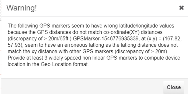
4. Note that while you upload any map on prime, you generally provide the map dimensions(in feets for x-y coordinates). Thus the prime would be calculating the distance between GPS coordinates that we feed in as GPS pointer to see if the error is not exceeding over 20m/65 feet from the dimensions of actual map uploaded. If there exists error margin exceeding 20m, then you continue to see below error message.
5. Once we export the map from prime and import it on CMX, make sure the GPS markers are shown green. If it is grey, then it means there exits error in the dimensions of GPS coordinates supplied on map.
a. GPS markers grey indicating improperly scaled latitude longitude values on map.
b. GPS marker green indicating correctly scaled latitude longitude values on map.
Find answers to your questions by entering keywords or phrases in the Search bar above. New here? Use these resources to familiarize yourself with the community:


