- Cisco Community
- Technology and Support
- Wireless - Mobility
- Wireless
- Prime Heat Map Automated Export
- Subscribe to RSS Feed
- Mark Topic as New
- Mark Topic as Read
- Float this Topic for Current User
- Bookmark
- Subscribe
- Mute
- Printer Friendly Page
Prime Heat Map Automated Export
- Mark as New
- Bookmark
- Subscribe
- Mute
- Subscribe to RSS Feed
- Permalink
- Report Inappropriate Content
05-29-2014 01:29 PM - edited 07-05-2021 12:54 AM
Is there a method whereby I could automatically export (in PDF/JPEG/PNG format) the Cisco Prime heat maps for wireless coverage?
Our organization would like to give access to this information without creating a limited/guest account in Cisco Prime Infrastructure.
- Labels:
-
Wireless Network Management
- Mark as New
- Bookmark
- Subscribe
- Mute
- Subscribe to RSS Feed
- Permalink
- Report Inappropriate Content
07-29-2014 11:58 AM
I would love such a feature!
@Cisco: Please give us this option or something similar to the Ekahau wireless reports which exports the info into a PDF / doc of choice for ease of sharing with non-technical partners.
Even if you took the current reporting method through Prime (Planning Mode - Generate Proposal) and made that into an exportable document vs. a static webpage would be great!
- Mark as New
- Bookmark
- Subscribe
- Mute
- Subscribe to RSS Feed
- Permalink
- Report Inappropriate Content
03-09-2016 08:39 AM
The proposal generation is great for project proposals for management, but the proposals are useless for installers as the maps lack detail and are unreadable. We want to export the heat maps as large images showing location of APs in detail.
- Mark as New
- Bookmark
- Subscribe
- Mute
- Subscribe to RSS Feed
- Permalink
- Report Inappropriate Content
08-14-2020 05:22 PM - edited 08-14-2020 05:23 PM
Hey,
this might be to late, but i wrote a small powershell script that will export the cisco prime maps and draw the access points. Should be an easy task to add a transparent brush that will display the heat mapping.
https://github.com/pieewiee/CiscoPrimeMapExport
- Mark as New
- Bookmark
- Subscribe
- Mute
- Subscribe to RSS Feed
- Permalink
- Report Inappropriate Content
08-01-2014 12:05 AM
Sorry, right now there is no such feature in Cisco Prime to do so where you can upload your own images.
- Mark as New
- Bookmark
- Subscribe
- Mute
- Subscribe to RSS Feed
- Permalink
- Report Inappropriate Content
08-05-2014 11:41 AM
To be clear, we are not asking to upload our own images to Prime (although that would also be a nice feature). We just want the ability to *export* Prime maps to a format suitable for external reports such as an image format (jpg, tiff) or even a PDF.
The current report feature Prime has is not useful in its current state. The maps are too small for one thing. It also is not editable.
Since the images and maps are already stored somewhere on Prime, even just a simple scp script for the maps *with all their location info and walls, etc* would be lovely.
See the reports Ekahau allows a user to create as an example of what we want.
- Mark as New
- Bookmark
- Subscribe
- Mute
- Subscribe to RSS Feed
- Permalink
- Report Inappropriate Content
08-22-2014 01:43 PM
At present no feature of automatic export
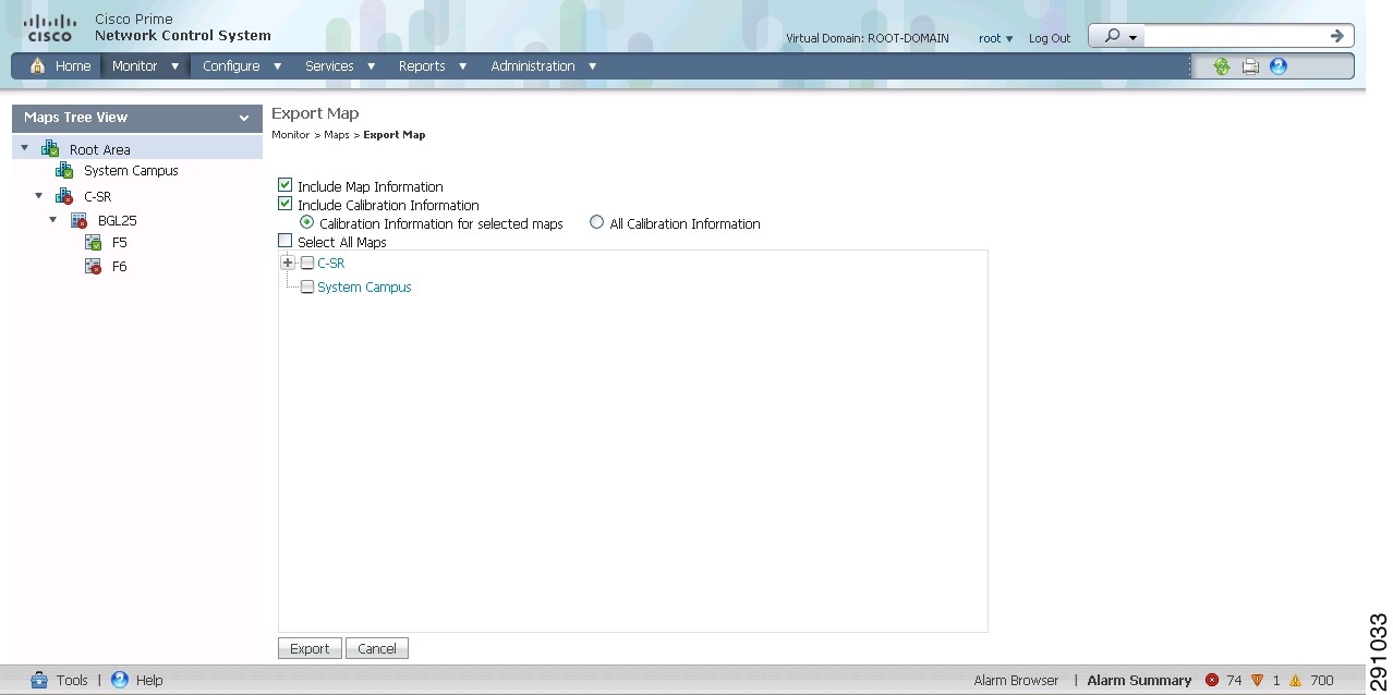
Exporting a Map
The Export Map feature allows you to export map or calibration information to XML. The exported XML will be in an encrypted format and will not be readable. XML and images are bundled, tarred, and zipped into a file for a successful import into another NCS.
To export a map, follow these steps:
Step 1 ![]() Choose Monitor > Site Maps page.
Choose Monitor > Site Maps page.
Step 2 ![]() From the Select a command drop-down list, Choose Export Maps. The Export Map page appears. (see Figure 6-9)
From the Select a command drop-down list, Choose Export Maps. The Export Map page appears. (see Figure 6-9)
Figure 6-9 Export Map

Step 3 ![]() Select the maps that you want to export.
Select the maps that you want to export.
Step 4 ![]() Click Export to export the selected map data.
Click Export to export the selected map data.
Discover and save your favorite ideas. Come back to expert answers, step-by-step guides, recent topics, and more.
New here? Get started with these tips. How to use Community New member guide
